
Distance-based fares change the game
Utah Transit Authority pioneers open-loop payments
By Glenn Swain
Seven years ago, seeing the future of transit fare collection moving from cash handling to electronic technology, Utah Transit Authority (UTA), Salt Lake, UT, was at a crossroads. Choosing correctly from the menu of emerging technologies to serve a 1,400-square-mile area that takes in Salt Lake, Box Elder, Davis, Tooele and Weber counties would be no easy task.
According to UTA General Manager Michael Allegra, in its investigation of open payment systems, the agency viewed fare collection no differently than any other credit card purchase for a product or service. Instead of a closed system that requires the customer to buy a medium from the agency or another source for use only by the transit system, UTA became one of the first transit agencies in the country to subscribe to an open payment electronic system using proximity readers, as well as the first transit system to consider a fee-per-mile approach to fare collection. The open payment pilot program ended in 2008 and was fully implemented in January 2009.
“In my 35 years with UTA, we have tried every possible means of fare collection — time of day, distance-based, quality of service and zonal payments,” says Allegra. “I think this is a game-changer in our business. Frankly, I think our industry is stuck in the past with always charging a simple and easy flat fare.”
Distance-based fare
UTA retained the consultant firm, CH2M HILL, Englewood, CO, to sort out the options for a distance-based system. The staff agreed that it must be easy for riders to understand and at the same time make transit service more attractive and convenient to use. The technology would also have to complement the GPS system already in place on each of the 500 UTA transit buses.
Once implemented, the tap-on/tap-off system will record the location where the customer boards and exits the bus and charge a fare based on time of day and distance traveled. Riders will no longer pay a flat fee to get to their destination.
“Unlike UTA’s current flat fare, the fee-per-mile will allow riders to pay for exactly what they use, and no more,” says Cyndy Pollan, director, Fare Strategies at CH2M HILL. “It is very different from what anyone else has implemented and clearly gets at some of the agency’s key objectives, one of which was to combine the idea of a distance-based fare with a significantly lower fare for someone only taking a short trip.”
“From a policy perspective this is the right thing to do,” Allegra says. “Comparing transit to a utility, users pay for electricity, gas and water by what they use. They should be able to view transit in the same light.”

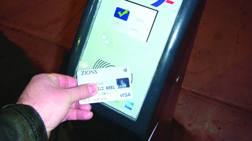
Pick a card, any card
UTA partnered with an entity called Isis, a consortium of major credit card companies and the major telephone companies, that essentially turns a cell phone into a mobile wallet. As a proximity reader, it does not require any new devices to read the phones.
According to the consultants at CH2M HILL, the UTA open fare system is not without its challenges.
“To the extent that UTA has rolled out the open payment system, it only works for somebody who wants to pay an adult cash fare,” says Pollan. “If I’m a senior entitled to a discount and I want to pay with my credit card, it will still charge me an adult cash fare. The system currently does not associate that card with a rider who is eligible for a discount.”
She sees this as a perfect example of what it will take to get this system to the next level.
Alan Cheng, program manager, Payment Systems at CH2M HILL, says other large transit agencies like New York, Washington DC, Chicago, and Philadelphia who are planning similar systems are fleshing out these issues.
“While there are problems to be ironed out, UTA still embraces the open fare system as its future,” says Cheng. “The vast amounts of data the agency can retrieve from each rider allow the agency to adjust routes as needed and provide better service.”
Data in; service out
According to Brin Owen, regional director, Payment Systems at CH2M HILL, a paper-based, cash-based system does not provide a lot of information about the riders; where they got on, get off and how long they ride.
“The amount of data from a given transaction is quite limited, whereas a smart card system provides extensive data,” he says. “Some agencies say a smart card system gives up so much information it is like trying to drink from a fire hose. Quite often, they turn to a consulting firm to understand how to best use and manage this data.”
Owen says more data gives a better picture of who is riding, and is of tremendous benefit to planning and finance departments, and in establishing routes, schedules, fares and fare products.

“Many institutions such as universities, businesses and organizations are subscribing to this electronic fare collection system,” Allegra says. “Our goal is to be totally cash-less by 2030.”
UTA says the reaction from customers has been positive thus far.
“We have been very accommodating,” Allegra says. “We initiated a grace period for the first three months in which we educated the community. We went to hard enforcement in late 2011. It is working fine. People love it because it’s simple.” BR
I will be very interested in how this goes as this is the first time any US transportation agency has implemented distance based fares onboard buses.
This has been the norm in Asia for decades and they were very successful with it and they managed to figure this out long before contactless cards were the norm.
In fact, it even changed the game to make mass transit agencies into mass transit corporations because of the revenues they made actually turned into profit. Said profits were then used to further enhance services than being reliant on government subsidies and taxes to keep them afloat.
One thing however that caught my attention is the use of GPS devices to track distance data. Asian buses were on the distance fare scheme long before GPS devices the norm. They made it simple: use the odometer of the bus. Same thing like the fare meter hooked up to the odometer on the taxi: odometer of the bus reads 89000 mi on tap in, odometer of the bus read 89005 mi on tap out, passenger traveled 5 miles.
This approach would be a simpler and perhaps a more cost effective way of doing than the GPS. Furthermore, it would also help in places where GPS devices can’t be used (i.e. skyscrapers in NYC blocking GPS signals, tunnels in Boston that can’t receive GPS signals, etc.)