CHK America responds to the psychology of transit mapping
By David Hubbard
Signage and graphics for public transportation falls under the general category of wayfinding, as much a philosophy as a navigational process that begins where traditional mapping leaves off. The objective is to present information for transit passengers to travel with minimal confusion, frustration and indecision in their journey by gleaning and whittling the available information down to a series of relevant steps.
—————————————————————————————————————————————
YOU MIGHT ALSO LIKE:
—————————————————————————————————————————————
Wayfinding specialists at CHK America, Inc., Santa Barbara, CA, work to alleviate the guesswork, applying only the most pertinent information. Wayfinding connects with how riders view and interpret information on complex public transportation systems. The company says simplicity is critical.
The eight-second rule
“We essentially have only eight seconds to provide an abundance of information that transit customers need before they become frustrated and walk away,” says CHK America President Rick Wood. “We call it their cognitive load, which can diminish greatly in a short time at a bus stop with so many distractions.”
He says to think of what life was like before Google Maps.
“We would write out directions on a napkin using only the most relevant streets and landmarks to denote a sense of place and the most direct route,” Wood says. “No one would ever take the time to designate every cross street and attraction along the way.”
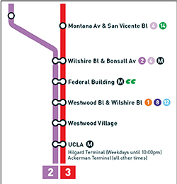
According to Wood, graphics are king. What appears on the napkin is a diagram that effectively communicates the language of the brain. Simply straightening streets and converting angles to 90-degrees makes it easier for a customer to interpret and apply the information.
“One basic principle we employ assumes all users are new to the system,” he says. “You are here orientation works for everyone at a bus stop. The directions are logical, simplified and easy for a new, busy or distracted seasoned traveler.”
The object is to boil down the information and focus on the next decision necessary at that point of the trip.
“Where am I?” Wood asks. “Where is my bus going? Am I headed in the right direction? Am I in the right place to board? This is what passengers need to know at each stop.”
CHK aims for standardization
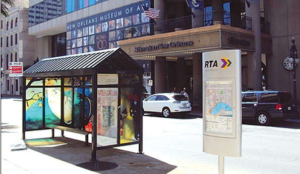
From its base in Santa Barbara, CHK has produced wayfinding signage and graphics for Gold Coast Transit, Santa Monica Big Blue Bus and Monterey-Salinas Transit. Anyone traveling the coast and taking public transit sees the information displayed in the exact same way in every city on every transit system.
Wood says, regardless of unique agency branding and specific information, wayfinding aspects can be structured similarly for every city.
“Why should someone travel from Phoenix to Chicago and have to figure out a completely different communication system?” he asks. “Ideally, as people travel into new areas, public transportation information should look the same for every system.”
The company says standardization requires a long-term effort, which begins with senior transit management making the wayfinding system a priority.
CHK America points to Washington Metropolitan Area Transit Authority (WMATA), Washington, D.C., for its exemplary commitment to creating a complete wayfinding system.
“From a customer information standpoint, WMATA is the best in the country,” Wood says. “London is the gold standard, but this is approaching a similar level. Building a system to this level takes a long time. We have been working with WMATA for over 10 years on more than 1,000 stops.”
Wayfinding standards typically employ graphics and symbols already in practice. Working with the standards already in place, Wood says people expect to see certain information represented in a certain way.
“If they are not, the graphics still have to appear extremely logical and instantly identifiable, such as handicap signs, restrooms, airports and hospitals,” he says. “If we deviate, we increase passengers’ cognitive load.”
According to Wood, a proprietary feature unique to his company is an indication of the time it takes to travel by bus to the destination stop.
“This is not about the bus running late,” he says. “Instead, it is simply a benchmark to help with trip planning and to keep a passenger from missing the intended stop. If it says the stop is seven minutes approximately, and the rider has been on the bus for 15 minutes, he may have missed his stop.”
Technology is not everything
Given all the available technology and focus on handheld phones and tablets, there is still a definite need for print. Wood says technology is only part of the wayfinding solution, pointing to a recent rider survey by Las Vegas RTA that revealed transit passengers wanted better print information at stops.
“Technology works optimally for short messages,” he says. “The message on the iPhone says the bus will arrive in three minutes— perfect. But where is the bus going? Does the agency really expect a passenger to figure out, on a phone screen, all the connections coming up on a 13-mile route? People can’t do that, nor do they really want to.”
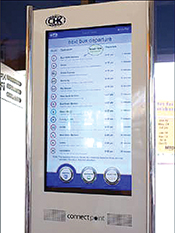
According to Wood, technology is a complement to traditional methods of presenting information. To that point, CHK America recently introduced an interactive kiosk in the Santa Barbara transit hub.
“Passengers interacting with the kiosk have time to do so between trips,” he says. “They have more time to explore, which is more difficult at the stop with noise and distractions from people walking by and traffic running in both directions.”

president and CEO, CHK America
On the move
Rick Wood studied accounting as a prerequisite to eventually owning his own business, which ultimately led to his launch of Maps.com. Ten years later, CHK London, a major distributor for Maps.com, expressed its desire to establish a foothold in U.S. transit and invited Wood to head up the new operation from his offices in Santa Barbara, CA. After 14 years, CHK America appears to be the go-to company for transit agency customer information.
Hampton Roads, VA, has an order for 3,000 new bus stops, for which CHK will fabricate the stops ourselves and cover the installation.
Most recently, Valley Metro, Phoenix, AZ, awarded the company its customer information design project, which includes consumer-focused light rail and bus connection maps and Guide-a-Rides, as well as local neighborhood maps to support all connectivity and pedestrian wayfinding.